
Make a donation
Gear up for your next adventure:
As an Amazon Associate, this site earns from qualifying purchases at no extra cost to you.
La Faute-sur-Mer topographic map
Click on the map to display elevation.
Make a donation
Gear up for your next adventure:
As an Amazon Associate, this site earns from qualifying purchases at no extra cost to you.
La Faute-sur-Mer
Le territoire municipal de La Faute-sur-Mer s’étend sur 726 hectares. L’altitude moyenne de la commune est de 3 mètres, avec des niveaux fluctuant entre 0 et 17 mètres.
Make a donation
Gear up for your next adventure:
As an Amazon Associate, this site earns from qualifying purchases at no extra cost to you.
About this map
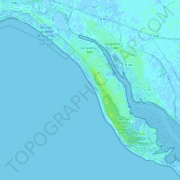
Name: La Faute-sur-Mer topographic map, elevation, terrain.
Average elevation: 1 m
Minimum elevation: -9 m
Maximum elevation: 11 m
Make a donation
Gear up for your next adventure:
As an Amazon Associate, this site earns from qualifying purchases at no extra cost to you.
Other topographic maps
Click on a map to view its topography, its elevation and its terrain.
Les Amourettes
France > Pays de la Loire > Vendée > L'Aiguillon-la-Presqu'île > La Faute-sur-Mer
Average elevation: 2 m
Les Violettes
France > Pays de la Loire > Vendée > L'Aiguillon-la-Presqu'île > La Faute-sur-Mer
Average elevation: 1 m
La Prise des Canons
France > Pays de la Loire > Vendée > L'Aiguillon-la-Presqu'île > L'Aiguillon-sur-Mer
Average elevation: 0 m
Lotissement des Beaumettes
France > Pays de la Loire > Vendée > L'Aiguillon-la-Presqu'île > La Faute-sur-Mer
Average elevation: 1 m
Make a donation
Gear up for your next adventure:
As an Amazon Associate, this site earns from qualifying purchases at no extra cost to you.
Lotissement des Chardonnerets
France > Pays de la Loire > Vendée > L'Aiguillon-la-Presqu'île > Lotissement des Chardonnerets
Average elevation: 2 m
Lotissement Les Sables d'Or
France > Pays de la Loire > Vendée > L'Aiguillon-la-Presqu'île > La Faute-sur-Mer
Average elevation: 2 m