
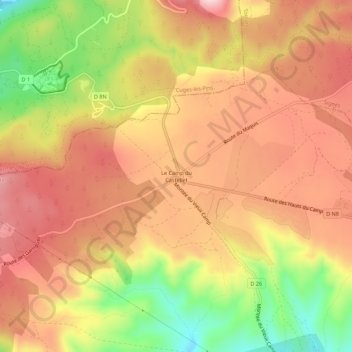
Le Camp du Castellet topographic map
Interactive map
Click on the map to display elevation.
About this map
Name: Le Camp du Castellet topographic map, elevation, terrain.
Average elevation: 371 m
Minimum elevation: 203 m
Maximum elevation: 483 m
Other topographic maps
Click on a map to view its topography, its elevation and its terrain.
Le Plan du Castellet
France > Provence-Alpes-Côte d'Azur > Var > Le Castellet
Le Plan du Castellet, Le Castellet, Toulon, Var, Provence-Alpes-Côte d'Azur, France métropolitaine, 83330, France
Average elevation: 143 m
Sainte Anne du Castellet
France > Provence-Alpes-Côte d'Azur > Var > Le Castellet
Sainte Anne du Castellet, Le Castellet, Toulon, Var, Provence-Alpes-Côte d'Azur, France métropolitaine, 83330, France
Average elevation: 201 m