
Make a donation
Gear up for your next adventure:
As an Amazon Associate, this site earns from qualifying purchases at no extra cost to you.
Greenville topographic map
Click on the map to display elevation.
Make a donation
Gear up for your next adventure:
As an Amazon Associate, this site earns from qualifying purchases at no extra cost to you.
Greenville
Greenville features a varied topography characterized by rolling hills and the nearby Blue Ridge Mountains. The city sits at an elevation of approximately 984 feet (300 meters) above sea level, with its landscape shaped significantly by the Reedy River, which flows through the heart of downtown, creating picturesque views and natural recreational areas. Surrounding Greenville, the terrain transitions into the mountainous regions to the north and east, offering scenic ridges and valleys that contribute to the area's biodiversity and unique microclimates. This mix of urban and natural environments not only enhances the aesthetic appeal but also provides numerous outdoor activities and scenic parks, making Greenville a vibrant place for residents and visitors alike.
Make a donation
Gear up for your next adventure:
As an Amazon Associate, this site earns from qualifying purchases at no extra cost to you.
About this map
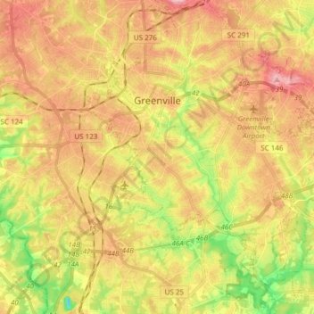
Name: Greenville topographic map, elevation, terrain.
Location: Greenville, Greenville County, South Carolina, United States (34.76654 -82.43624 34.89260 -82.28689)
Average elevation: 290 m
Minimum elevation: 200 m
Maximum elevation: 408 m
Make a donation
Gear up for your next adventure:
As an Amazon Associate, this site earns from qualifying purchases at no extra cost to you.
Other topographic maps
Click on a map to view its topography, its elevation and its terrain.
Make a donation
Gear up for your next adventure:
As an Amazon Associate, this site earns from qualifying purchases at no extra cost to you.
Marietta
United States > South Carolina > Greenville County > Slater-Marietta
Average elevation: 317 m
Make a donation
Gear up for your next adventure:
As an Amazon Associate, this site earns from qualifying purchases at no extra cost to you.
Isaqueena Park
United States > South Carolina > Greenville County > Greenville
Average elevation: 297 m
Make a donation
Gear up for your next adventure:
As an Amazon Associate, this site earns from qualifying purchases at no extra cost to you.
Cleveland Forest
United States > South Carolina > Greenville County > Greenville
Average elevation: 287 m
Make a donation
Gear up for your next adventure:
As an Amazon Associate, this site earns from qualifying purchases at no extra cost to you.
Sherwood Forest
United States > South Carolina > Greenville County > Greenville
Average elevation: 293 m
Little Table Rock Mountain
United States > South Carolina > Greenville County
Average elevation: 892 m
Make a donation
Gear up for your next adventure:
As an Amazon Associate, this site earns from qualifying purchases at no extra cost to you.
Mount Vernon Estates
United States > South Carolina > Greenville County > Greer
Average elevation: 302 m
Orchard Acres
United States > South Carolina > Greenville County > Wade Hampton
Average elevation: 292 m
Piney Ridge
United States > South Carolina > Greenville County > Wade Hampton
Average elevation: 304 m
Make a donation
Gear up for your next adventure:
As an Amazon Associate, this site earns from qualifying purchases at no extra cost to you.
Crescentwood Village
United States > South Carolina > Greenville County > Mauldin
Average elevation: 276 m
Make a donation
Gear up for your next adventure:
As an Amazon Associate, this site earns from qualifying purchases at no extra cost to you.
Morningside
United States > South Carolina > Greenville County > Wade Hampton
Average elevation: 300 m
Evergreen Place
United States > South Carolina > Greenville County > Greenville
Average elevation: 288 m
Make a donation
Gear up for your next adventure:
As an Amazon Associate, this site earns from qualifying purchases at no extra cost to you.
Make a donation
Gear up for your next adventure:
As an Amazon Associate, this site earns from qualifying purchases at no extra cost to you.
Glenwood Acres
United States > South Carolina > Greenville County > Greenville
Average elevation: 305 m