
Tongres topographic map
Interactive map
Click on the map to display elevation.
About this map
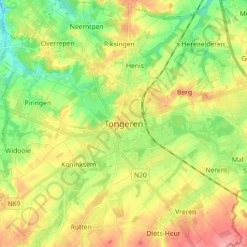
Name: Tongres topographic map, elevation, terrain.
Location: Tongres, Limbourg, Flandre, 3700, Belgique (50.74063 5.42392 50.82063 5.50392)
Average elevation: 95 m
Minimum elevation: 54 m
Maximum elevation: 144 m
Other topographic maps
Click on a map to view its topography, its elevation and its terrain.