
Make a donation
Gear up for your next adventure:
As an Amazon Associate, this site earns from qualifying purchases at no extra cost to you.
Butuan topographic map
Click on the map to display elevation.
Make a donation
Gear up for your next adventure:
As an Amazon Associate, this site earns from qualifying purchases at no extra cost to you.
Butuan
Butuan is located at 8°57′N 125°32′E / 8.95°N 125.53°E / 8.95; 125.53. Elevation at these coordinates is estimated at 1.0 meter above sea level (M.a.s.l.).
Make a donation
Gear up for your next adventure:
As an Amazon Associate, this site earns from qualifying purchases at no extra cost to you.
About this map
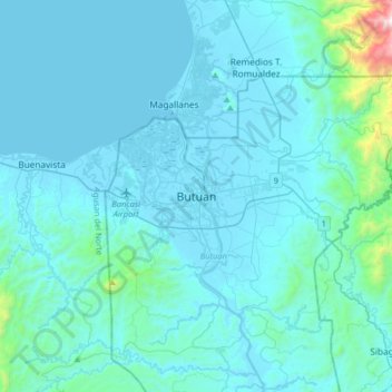
Name: Butuan topographic map, elevation, terrain.
Location: Butuan, Agusan del Norte, Caraga, 8600, Philippines (8.78833 125.37694 9.10833 125.69694)
Average elevation: 115 m
Minimum elevation: 0 m
Maximum elevation: 1,732 m
Make a donation
Gear up for your next adventure:
As an Amazon Associate, this site earns from qualifying purchases at no extra cost to you.