
Canindeyú topographic map
Interactive map
Click on the map to display elevation.
About this map
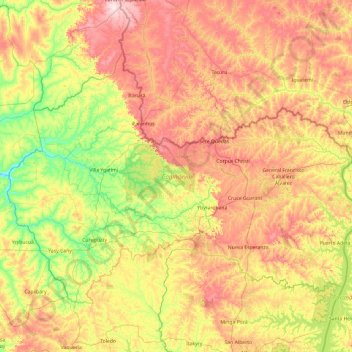
Name: Canindeyú topographic map, elevation, terrain.
Location: Canindeyú, Región Oriental, Paraguay (-24.78397 -56.17278 -23.52359 -54.25800)
Average elevation: 290 m
Minimum elevation: 101 m
Maximum elevation: 599 m
Other topographic maps
Click on a map to view its topography, its elevation and its terrain.
Beni Loma
Paraguay > Department of Paraguari > District of Carapeguá
Beni Loma, District of Carapeguá, Department of Paraguari, Región Oriental, Paraguay
Average elevation: 107 m