
Las Tejerías topographic map
Interactive map
Click on the map to display elevation.
About this map
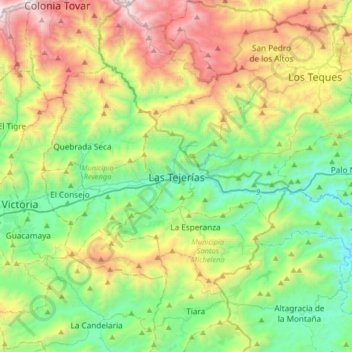
Name: Las Tejerías topographic map, elevation, terrain.
Average elevation: 1,003 m
Minimum elevation: 318 m
Maximum elevation: 2,382 m
Other topographic maps
Click on a map to view its topography, its elevation and its terrain.
Curiepe
Venezuela > Estado Aragua > Municipio Santos Michelena
Curiepe, Parroquia Santos Michelena, Municipio Santos Michelena, Estado Aragua, 2119, Venezuela
Average elevation: 676 m
Tiara
Venezuela > Estado Aragua > Municipio Santos Michelena > Tiara
Tiara, Parroquia Tiara, Municipio Santos Michelena, Estado Aragua, Venezuela
Average elevation: 885 m