
Make a donation
Gear up for your next adventure:
As an Amazon Associate, this site earns from qualifying purchases at no extra cost to you.
Towcester topographic map
Click on the map to display elevation.
Make a donation
Gear up for your next adventure:
As an Amazon Associate, this site earns from qualifying purchases at no extra cost to you.
Towcester
St. Lawrence's C of E Church, stands in the middle of the town. It has a 12th-century Norman transitional ground plan and foundation, probably laid over a Saxon 10th century stone building. Its ecclesiastical heritage may well relate back to Roman times as St Lawrence was patron saint of the Roman legions. The building was reconstructed in the perpendicular style 1480–85 when the church tower was added. The tower contains 12 bells generally accepted by ringers across the country to be one of the finest sets in the Midlands. The bells were moved in 1994 from Todmorden in Yorkshire. Permission to quarry stone for this restoration from Whittlewood Forest was granted by Edward IV and later confirmed by Richard III on his way towards Leicestershire and his death at the Battle of Bosworth Field. The church contains a "Treacle" Bible, a table tomb and cadaver of Archdeacon Sponne, Rector 1422–1448. The Archdeacon started the second oldest grammar school in Northamptonshire but the oldest one in the United Kingdom, which was merged with the old secondary modern school in Towcester to produce Sponne School. It is also claimed that Pope Boniface VIII was a rector of the church before his elevation to the position of pope. The church tower contains a peal of 12 bells and a chime of 9 bells.
Make a donation
Gear up for your next adventure:
As an Amazon Associate, this site earns from qualifying purchases at no extra cost to you.
About this map
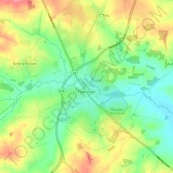
Name: Towcester topographic map, elevation, terrain.
Location: Towcester, West Northamptonshire, England, United Kingdom (52.10412 -1.03535 52.16501 -0.95726)
Average elevation: 111 m
Minimum elevation: 78 m
Maximum elevation: 158 m
Make a donation
Gear up for your next adventure:
As an Amazon Associate, this site earns from qualifying purchases at no extra cost to you.
Other topographic maps
Click on a map to view its topography, its elevation and its terrain.