
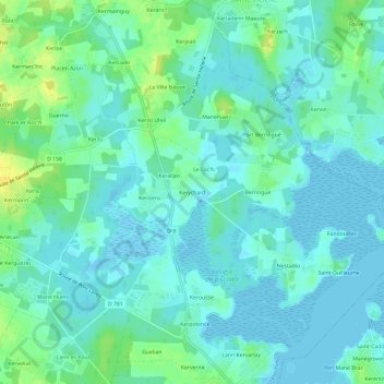
Kerychard topographic map
Interactive map
Click on the map to display elevation.
About this map
Name: Kerychard topographic map, elevation, terrain.
Average elevation: 6 m
Minimum elevation: -2 m
Maximum elevation: 22 m
Other topographic maps
Click on a map to view its topography, its elevation and its terrain.
Lannic Gorée
France > Bretagne > Morbihan > Plouhinec
Lannic Gorée, Plouhinec, Lorient, Morbihan, Bretagne, France métropolitaine, 56680, France
Average elevation: 11 m
L’Hermitage
France > Bretagne > Morbihan > Plouhinec
L’Hermitage, Plouhinec, Lorient, Morbihan, Bretagne, France métropolitaine, 56680, France
Average elevation: 17 m
Mané Kerzine
France > Bretagne > Morbihan > Plouhinec
Mané Kerzine, Plouhinec, Lorient, Morbihan, Bretagne, France métropolitaine, 56680, France
Average elevation: 8 m
Le Pontoir
France > Bretagne > Morbihan > Plouhinec > Le Pontoir
Le Pontoir, Plouhinec, Lorient, Morbihan, Bretagne, France métropolitaine, 56680, France
Average elevation: 12 m
Mané Pillieu
France > Bretagne > Morbihan > Plouhinec > Mané Pillieu
Mané Pillieu, Plouhinec, Lorient, Morbihan, Bretagne, France métropolitaine, 56680, France
Average elevation: 7 m