
Make a donation
Gear up for your next adventure:
As an Amazon Associate, this site earns from qualifying purchases at no extra cost to you.
St.Georgen topographic map
Click on the map to display elevation.
Make a donation
Gear up for your next adventure:
As an Amazon Associate, this site earns from qualifying purchases at no extra cost to you.
St.Georgen
St. Georgen (auch St. Georgen an der Ahr; italienisch: San Giorgio) ist eine Fraktion der Stadt Bruneck in Südtirol (Italien) mit etwas über 2275 Einwohnern und liegt auf 832 m Höhe.
Make a donation
Gear up for your next adventure:
As an Amazon Associate, this site earns from qualifying purchases at no extra cost to you.
About this map
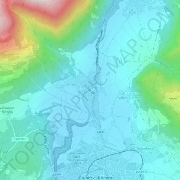
Name: St.Georgen topographic map, elevation, terrain.
Average elevation: 981 m
Minimum elevation: 813 m
Maximum elevation: 1,736 m
Make a donation
Gear up for your next adventure:
As an Amazon Associate, this site earns from qualifying purchases at no extra cost to you.
Other topographic maps
Click on a map to view its topography, its elevation and its terrain.