
Borough of Rossendale topographic map
Interactive map
Click on the map to display elevation.
About this map
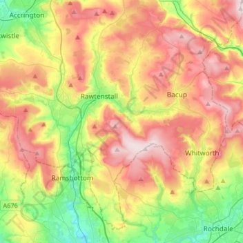
Name: Borough of Rossendale topographic map, elevation, terrain.
Location: Borough of Rossendale, Lancashire, England, United Kingdom (53.61451 -2.41101 53.75503 -2.14515)
Average elevation: 273 m
Minimum elevation: 89 m
Maximum elevation: 478 m
Other topographic maps
Click on a map to view its topography, its elevation and its terrain.
Colne Water
United Kingdom > England > Lancashire > Borough of Pendle > Laneshaw Bridge
Colne Water, Laneshaw Bridge, Borough of Pendle, Lancashire, England, United Kingdom
Average elevation: 202 m
Lancaster
United Kingdom > England > Lancashire
Lancaster, Lancashire, England, United Kingdom
Average elevation: 84 m
Preston
United Kingdom > England > Lancashire
Preston, Lancashire, England, United Kingdom
Average elevation: 58 m
Chorley
United Kingdom > England > Lancashire
Chorley, Lancashire, England, United Kingdom
Average elevation: 113 m
Trough Gate
United Kingdom > England > Lancashire > Borough of Rossendale > Britannia
Trough Gate, Whitworth, Britannia, Borough of Rossendale, Lancashire, England, OL13 9SN, United Kingdom
Average elevation: 341 m
Burnley
United Kingdom > England > Lancashire
Burnley, Lancashire, England, United Kingdom
Average elevation: 247 m
Haslingden Grane
United Kingdom > England > Lancashire > Borough of Rossendale > Haslingden
Haslingden Grane, Haslingden, Borough of Rossendale, Lancashire, England, BB4 4AU, United Kingdom
Average elevation: 287 m
Longridge Fell
United Kingdom > England > Lancashire > Ribble Valley
Longridge Fell, Ribble Valley, Lancashire, England, BB7 3LY, United Kingdom
Average elevation: 218 m
Fulwood Row
United Kingdom > England > Lancashire > Preston
Fulwood Row, Preston, Lancashire, England, PR2 9PD, United Kingdom
Average elevation: 53 m
Broughton
United Kingdom > England > Lancashire > Preston
Broughton, Preston, Lancashire, England, United Kingdom
Average elevation: 43 m
Goosnargh
United Kingdom > England > Lancashire > Preston
Goosnargh, Preston, Lancashire, England, PR3 2BB, United Kingdom
Average elevation: 67 m
Hesketh Lane
United Kingdom > England > Lancashire > Ribble Valley
Hesketh Lane, Chipping, Ribble Valley, Lancashire, England, PR3 2TH, United Kingdom
Average elevation: 131 m
Mellor
United Kingdom > England > Lancashire > Ribble Valley
Mellor, Ribble Valley, Lancashire, England, United Kingdom
Average elevation: 139 m
Haggate
United Kingdom > England > Lancashire > Burnley
Haggate, Burnley, Lancashire, England, BB10 3QH, United Kingdom
Average elevation: 220 m
Catlow
United Kingdom > England > Lancashire > Borough of Pendle > Nelson
Catlow, Nelson, Borough of Pendle, Lancashire, England, BB10 3RL, United Kingdom
Average elevation: 243 m
Fold Head
United Kingdom > England > Lancashire > Borough of Rossendale > Healey
Fold Head, Whitworth, Healey, Borough of Rossendale, Lancashire, England, OL12 8XL, United Kingdom
Average elevation: 294 m
Fence
United Kingdom > England > Lancashire > Borough of Pendle
Fence, Borough of Pendle, Lancashire, England, BB12 9EE, United Kingdom
Average elevation: 187 m
Becconsall
United Kingdom > England > Lancashire > West Lancashire
Becconsall, West Lancashire, Lancashire, England, PR4 6SN, United Kingdom
Average elevation: 10 m
Lower Bartle
United Kingdom > England > Lancashire > Preston > Woodplumpton
Lower Bartle, Woodplumpton, Preston, Lancashire, England, PR4 0RX, United Kingdom
Average elevation: 30 m
Rivington Pike
United Kingdom > England > Lancashire > Horwich
Rivington Pike, Georges Lane, Rivington, Horwich, Chorley, Lancashire, Greater Manchester, England, BL6 6RU, United Kingdom
Average elevation: 270 m
Borough of Fylde
United Kingdom > England > Lancashire
Borough of Fylde, Lancashire, England, United Kingdom
Average elevation: 13 m
White Coppice
United Kingdom > England > Lancashire > Chorley
White Coppice, Anglezarke, Chorley, Lancashire, England, PR6 9DB, United Kingdom
Average elevation: 184 m
Lancaster Canal
United Kingdom > England > Lancashire
Lancaster Canal, Lancashire, England, United Kingdom
Average elevation: 98 m
Hardhorn
United Kingdom > England > Lancashire > Borough of Wyre
Hardhorn, Borough of Wyre, Lancashire, England, FY6 8DN, United Kingdom
Average elevation: 13 m
Little Thornton
United Kingdom > England > Lancashire > Borough of Wyre
Little Thornton, Borough of Wyre, Lancashire, England, FY5 5LU, United Kingdom
Average elevation: 8 m
Silverdale
United Kingdom > England > Lancashire > Lancaster
Silverdale, Lancaster, Lancashire, England, United Kingdom
Average elevation: 16 m
Lytham St Annes
United Kingdom > England > Lancashire > Borough of Fylde
Lytham St Annes, Borough of Fylde, Lancashire, England, FY8 4AR, United Kingdom
Average elevation: 5 m
Samlesbury
United Kingdom > England > Lancashire > South Ribble
Samlesbury, South Ribble, Lancashire, England, United Kingdom
Average elevation: 58 m
Arkholme
United Kingdom > England > Lancashire > Lancaster
Arkholme, Lancaster, Lancashire, England, LA6 1RA, United Kingdom
Average elevation: 57 m
Read
United Kingdom > England > Lancashire > Ribble Valley
Read, Ribble Valley, Lancashire, England, United Kingdom
Average elevation: 114 m
Stodday
United Kingdom > England > Lancashire > Lancaster
Stodday, Aldcliffe-with-Stodday, Lancaster, Lancashire, England, LA2 0AG, United Kingdom
Average elevation: 26 m
Over Kellet
United Kingdom > England > Lancashire > Lancaster
Over Kellet, Lancaster, Lancashire, England, United Kingdom
Average elevation: 69 m
West Lancashire
United Kingdom > England > Lancashire
West Lancashire, Lancashire, England, United Kingdom
Average elevation: 30 m
Whitewell Bottom
United Kingdom > England > Lancashire > Borough of Rossendale > Sagar Holme
Whitewell Bottom, Sagar Holme, Borough of Rossendale, Lancashire, England, BB4 9DE, United Kingdom
Average elevation: 281 m
Gisburn
United Kingdom > England > Lancashire > Ribble Valley
Gisburn, Ribble Valley, Lancashire, England, United Kingdom
Average elevation: 160 m
Hayshaw Fell
United Kingdom > England > Lancashire > Lancaster
Hayshaw Fell, Over Wyresdale, Lancaster, Lancashire, England, LA2 9DW, United Kingdom
Average elevation: 226 m
Old Langho
United Kingdom > England > Lancashire > Ribble Valley > Brockhall Village
Old Langho, Billington and Langho, Brockhall Village, Ribble Valley, Lancashire, England, BB6 8AP, United Kingdom
Average elevation: 74 m
Wray-with-Botton
United Kingdom > England > Lancashire > Lancaster
Wray-with-Botton, Lancaster, Lancashire, England, United Kingdom
Average elevation: 261 m
Parlick
United Kingdom > England > Lancashire > Borough of Wyre
Parlick, Borough of Wyre, Lancashire, England, PR3 2NZ, United Kingdom
Average elevation: 251 m
Warton Crag
United Kingdom > England > Lancashire > Lancaster > Warton
Warton Crag, Trig Point to Cleft Stone, Warton, Lancaster, Lancashire, England, LA5 9NE, United Kingdom
Average elevation: 45 m
Billington and Langho
United Kingdom > England > Lancashire > Ribble Valley > Brockhall Village
Billington and Langho, Brockhall Village, Ribble Valley, Lancashire, England, United Kingdom, Chew Bank Wood
Average elevation: 58 m
Brungerley Park
United Kingdom > England > Lancashire > Ribble Valley > Clitheroe > Waddington
Brungerley Park, Clitheroe, Waddington, Ribble Valley, Lancashire, England, United Kingdom
Average elevation: 77 m
Leyland
United Kingdom > England > Lancashire > South Ribble
Leyland, South Ribble, Lancashire, England, PR25 2EX, United Kingdom
Average elevation: 41 m
Warton Bank
United Kingdom > England > Lancashire > Borough of Fylde > Warton
Warton Bank, Bryning-with-Warton, Warton, Borough of Fylde, Lancashire, England, PR4 1TB, United Kingdom
Average elevation: 8 m
Forest of Bowland AONB
United Kingdom > England > Lancashire
Forest of Bowland AONB, Lancashire, England, United Kingdom
Average elevation: 201 m
Billington
United Kingdom > England > Lancashire > Ribble Valley
Billington, Ribble Valley, Lancashire, England, BB7 9NG, United Kingdom
Average elevation: 89 m
Ewood Bridge
United Kingdom > England > Lancashire > Borough of Rossendale
Ewood Bridge, Borough of Rossendale, Lancashire, England, BB4 6LZ, United Kingdom
Average elevation: 226 m
Whitewell
United Kingdom > England > Lancashire > Ribble Valley
Whitewell, Bowland Forest Low, Ribble Valley, Lancashire, England, BB7 3AT, United Kingdom
Average elevation: 184 m
Ormskirk
United Kingdom > England > Lancashire > West Lancashire
Ormskirk, West Lancashire, Lancashire, England, L39 2XN, United Kingdom
Average elevation: 39 m
Capernwray
United Kingdom > England > Lancashire > Lancaster
Capernwray, Over Kellet, Lancaster, Lancashire, England, LA6 1AE, United Kingdom
Average elevation: 60 m