
Bandarban Hill District topographic map
Interactive map
Click on the map to display elevation.
About this map
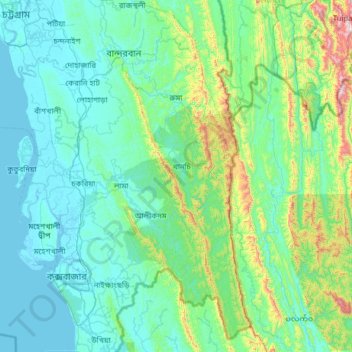
Name: Bandarban Hill District topographic map, elevation, terrain.
Location: Bandarban Hill District, Chattogram Division, Bangladesh (21.19983 92.06690 22.37488 92.68020)
Average elevation: 190 m
Minimum elevation: -2 m
Maximum elevation: 1,597 m
Other topographic maps
Click on a map to view its topography, its elevation and its terrain.
Chattogram
Bangladesh > Chattogram Division > Chattogram
Chittagong lies at 22°22′0″N 91°48′0″E / 22.36667°N 91.80000°E / 22.36667; 91.80000. It straddles the coastal foothills of the Chittagong Hill Tracts in southeastern Bangladesh. The Karnaphuli River runs along the southern banks of the city, including its central business district. The…
Average elevation: 6 m
Cox's Bazar
Bangladesh > Chattogram Division
Cox's Bazar lies on a coastal plain in the southeastern corner of Bangladesh. From above, the plain appears to bulge out into the Bay of Bengal. Along the shore is an extensive area of beach and dunes. Most of the city is built on a floodplain that is lower in elevation than the dunes, making it more…
Average elevation: 8 m
Kaptai National Park,Kaptai, Rangamati.
Bangladesh > Chattogram Division > Rajasthali Upazila
Average elevation: 85 m
Waggachara Tea Estate
Bangladesh > Chattogram Division > Rangamati Hill District
Average elevation: 64 m