
Wonderboom Nature Reserve topographic map
Interactive map
Click on the map to display elevation.
About this map
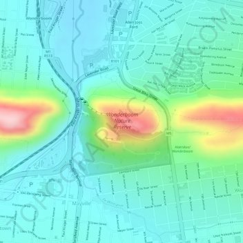
Name: Wonderboom Nature Reserve topographic map, elevation, terrain.
Average elevation: 1,277 m
Minimum elevation: 1,224 m
Maximum elevation: 1,444 m
Other topographic maps
Click on a map to view its topography, its elevation and its terrain.
Tshwane Ward 80
Tshwane Ward 80, Pretoria, City of Tshwane Metropolitan Municipality, Gauteng, RSA
Average elevation: 1,357 m
Tshwane Ward 46
Tshwane Ward 46, Pretoria, City of Tshwane Metropolitan Municipality, Gauteng, RSA
Average elevation: 1,396 m
Tshwane Ward 7
Tshwane Ward 7, Pretoria, City of Tshwane Metropolitan Municipality, Gauteng, RSA
Average elevation: 1,367 m
Tshwane Ward 92
Tshwane Ward 92, Pretoria, City of Tshwane Metropolitan Municipality, Gauteng, RSA
Average elevation: 1,351 m
Tshwane Ward 102
Tshwane Ward 102, Pretoria, City of Tshwane Metropolitan Municipality, Gauteng, RSA
Average elevation: 1,472 m
Magaliesberg Nature Area
Magaliesberg Nature Area, Birdflower Road, Tshwane Ward 7, Pretoria, City of Tshwane Metropolitan Municipality, Gauteng, RSA
Average elevation: 1,386 m
Tshwane Ward 56
Tshwane Ward 56, Pretoria, City of Tshwane Metropolitan Municipality, Gauteng, RSA
Average elevation: 1,380 m
Tshwane Ward 3
Tshwane Ward 3, Pretoria, City of Tshwane Metropolitan Municipality, Gauteng, RSA
Average elevation: 1,399 m
Tshwane Ward 55
Tshwane Ward 55, Pretoria, City of Tshwane Metropolitan Municipality, Gauteng, RSA
Average elevation: 1,334 m
Tshwane Ward 44
Tshwane Ward 44, Pretoria, City of Tshwane Metropolitan Municipality, Gauteng, 0043, RSA
Average elevation: 1,406 m
Tshwane Ward 84
Tshwane Ward 84, Pretoria, City of Tshwane Metropolitan Municipality, Gauteng, RSA
Average elevation: 1,322 m