
San Pedro de Atacama topographic map
Interactive map
Click on the map to display elevation.
San Pedro de Atacama
The town lies at an average of 8,000 feet (2,400 m), thus visitors often experience mild altitude sickness such as dizziness, lethargy and headaches. The local climate is extremely dry and mild, with daytime temperatures between 25–30 degrees Celsius (77–86 degrees Fahrenheit) in the summer (December to February) and 18–25 °C (64–77 °F) in the winter (June to August). Nighttime temperatures routinely drop below 0 °C (32 °F) and can reach as low as −10 °C (14 °F) in the winter. The record high temperature of 38.3 °C (100.9 °F) was registered in January 2024 in San Pedro de Atacama.
About this map
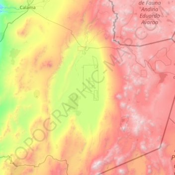
Name: San Pedro de Atacama topographic map, elevation, terrain.
Average elevation: 3,428 m
Minimum elevation: 1,560 m
Maximum elevation: 6,150 m