
Make a donation
Gear up for your next adventure:
As an Amazon Associate, this site earns from qualifying purchases at no extra cost to you.
Levertsweiler topographic map
Click on the map to display elevation.
Make a donation
Gear up for your next adventure:
As an Amazon Associate, this site earns from qualifying purchases at no extra cost to you.
About this map
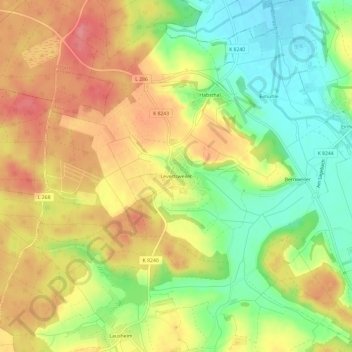
Name: Levertsweiler topographic map, elevation, terrain.
Average elevation: 623 m
Minimum elevation: 578 m
Maximum elevation: 665 m
Make a donation
Gear up for your next adventure:
As an Amazon Associate, this site earns from qualifying purchases at no extra cost to you.
Other topographic maps
Click on a map to view its topography, its elevation and its terrain.
Pfrunger-Burgweiler Ried
Deutschland > Baden-Württemberg > Landkreis Sigmaringen > Ostrach
Das heute rund 1015 Hektar große Naturschutzgebiet Pfrunger-Burgweiler Ried gehört naturräumlich zum Oberschwäbischen Hügelland. Es liegt etwa drei Kilometer südlich der Ostracher Ortsmitte und schließt unmittelbar nordwestlich an Wilhelmsdorf an. Es liegt auf einer Höhe von ungefähr 610 m ü. NHN und…
Average elevation: 639 m
Levertsweiler
Deutschland > Baden-Württemberg > Landkreis Sigmaringen > Ostrach
Average elevation: 624 m