
Thank you for supporting this site ❤️
Make a donation
Make a donation
Gear up for your next adventure:
As an Amazon Associate, this site earns from qualifying purchases at no extra cost to you.
Ruivães topographic map
Click on the map to display elevation.
Thank you for supporting this site ❤️
Make a donation
Make a donation
Gear up for your next adventure:
As an Amazon Associate, this site earns from qualifying purchases at no extra cost to you.
About this map
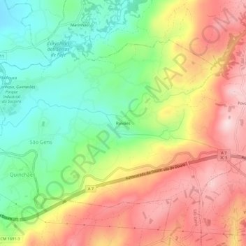
Name: Ruivães topographic map, elevation, terrain.
Location: Ruivães, São Gens, Fafe, Braga, 4820-590, Portugal (41.42999 -8.13675 41.46999 -8.09675)
Average elevation: 533 m
Minimum elevation: 362 m
Maximum elevation: 723 m
Thank you for supporting this site ❤️
Make a donation
Make a donation
Gear up for your next adventure:
As an Amazon Associate, this site earns from qualifying purchases at no extra cost to you.