
Make a donation
Gear up for your next adventure:
As an Amazon Associate, this site earns from qualifying purchases at no extra cost to you.
Bidhannagar topographic map
Click on the map to display elevation.
Make a donation
Gear up for your next adventure:
As an Amazon Associate, this site earns from qualifying purchases at no extra cost to you.
Bidhannagar
Bidhannagar is located at 22°35′N 88°25′E / 22.58°N 88.42°E / 22.58; 88.42. It has an average elevation of 11 metres (49 ft).
Make a donation
Gear up for your next adventure:
As an Amazon Associate, this site earns from qualifying purchases at no extra cost to you.
About this map
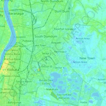
Name: Bidhannagar topographic map, elevation, terrain.
Location: Bidhannagar, North 24 Parganas, West Bengal, India (22.52256 88.39537 22.66731 88.47461)
Average elevation: 5 m
Minimum elevation: -3 m
Maximum elevation: 23 m
Make a donation
Gear up for your next adventure:
As an Amazon Associate, this site earns from qualifying purchases at no extra cost to you.
Other topographic maps
Click on a map to view its topography, its elevation and its terrain.
Make a donation
Gear up for your next adventure:
As an Amazon Associate, this site earns from qualifying purchases at no extra cost to you.