
Thank you for supporting this site ❤️
Make a donation
Make a donation
Gear up for your next adventure:
As an Amazon Associate, this site earns from qualifying purchases at no extra cost to you.
Peddapalli topographic map
Click on the map to display elevation.
Thank you for supporting this site ❤️
Make a donation
Make a donation
Gear up for your next adventure:
As an Amazon Associate, this site earns from qualifying purchases at no extra cost to you.
About this map
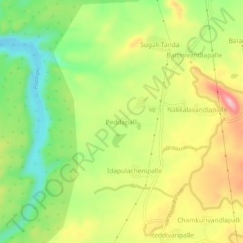
Name: Peddapalli topographic map, elevation, terrain.
Location: Peddapalli, Galiveedu, Annamayya, Andhra Pradesh, India (14.07993 78.49248 14.11993 78.53248)
Average elevation: 377 m
Minimum elevation: 281 m
Maximum elevation: 488 m
Thank you for supporting this site ❤️
Make a donation
Make a donation
Gear up for your next adventure:
As an Amazon Associate, this site earns from qualifying purchases at no extra cost to you.