Cheltenham topographic map
Interactive map
Click on the map to display elevation.
About this map
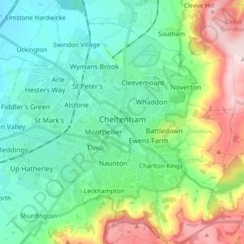
Name: Cheltenham topographic map, elevation, terrain.
Location: Cheltenham, Gloucestershire, England, United Kingdom (51.85833 -2.14304 51.93887 -2.01022)
Average elevation: 109 m
Minimum elevation: 22 m
Maximum elevation: 329 m
Other topographic maps
Click on a map to view its topography, its elevation and its terrain.
Painswick
United Kingdom > England > Gloucestershire
Painswick, Stroud, Gloucestershire, England, United Kingdom
Average elevation: 163 m
Cirencester
United Kingdom > England > Gloucestershire > Cotswold District > Chesterton
Cirencester, Chesterton, Cotswold District, Gloucestershire, England, United Kingdom
Average elevation: 128 m
Gloucester
United Kingdom > England > Gloucestershire
Gloucester, Gloucestershire, England, United Kingdom
Average elevation: 36 m