
Park Molenwijk topographic map
Interactive map
Click on the map to display elevation.
About this map
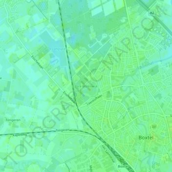
Name: Park Molenwijk topographic map, elevation, terrain.
Location: Park Molenwijk, Boxtel, Noord-Brabant, Nederland (51.59310 5.30613 51.59967 5.31325)
Average elevation: 8 m
Minimum elevation: 3 m
Maximum elevation: 12 m
Other topographic maps
Click on a map to view its topography, its elevation and its terrain.
De Roond
Nederland > Noord-Brabant > Boxtel
De Roond, Boxtel, Noord-Brabant, Nederland, 5281 SG, Nederland
Average elevation: 9 m
Langenberg
Nederland > Noord-Brabant > Boxtel > Langenberg
Langenberg, Boxtel, Noord-Brabant, Nederland, 5294, Nederland
Average elevation: 8 m