
Make a donation
Gear up for your next adventure:
As an Amazon Associate, this site earns from qualifying purchases at no extra cost to you.
Vulamehlo Local Municipality topographic map
Click on the map to display elevation.
Make a donation
Gear up for your next adventure:
As an Amazon Associate, this site earns from qualifying purchases at no extra cost to you.
About this map
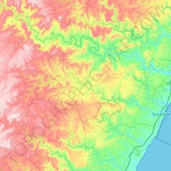
Name: Vulamehlo Local Municipality topographic map, elevation, terrain.
Average elevation: 421 m
Minimum elevation: 0 m
Maximum elevation: 1,049 m
Make a donation
Gear up for your next adventure:
As an Amazon Associate, this site earns from qualifying purchases at no extra cost to you.
Other topographic maps
Click on a map to view its topography, its elevation and its terrain.
Port Shepstone
South Africa > KwaZulu-Natal > Ugu District Municipality > Hibiscus Coast Local Municipality
Port Shepstone's topography is characterised by a rugged/hilly terrain with the Central Business District (CBD) lying on a large hill overlooking the Indian Ocean. Port Shepstone proper (excluding its extensions) is bordered by the uMzimkhulu River to the north and the N2 freeway to the east and is also…
Average elevation: 33 m
uMgeni
South Africa > KwaZulu-Natal > Ugu District Municipality > Umzumbe Local Municipality
Average elevation: 177 m
Palm Beach
South Africa > KwaZulu-Natal > Ugu District Municipality > Hibiscus Coast Local Municipality
Average elevation: 31 m
Margate
South Africa > KwaZulu-Natal > Ugu District Municipality > Hibiscus Coast Local Municipality
Average elevation: 45 m
Make a donation
Gear up for your next adventure:
As an Amazon Associate, this site earns from qualifying purchases at no extra cost to you.
Glenmore
South Africa > KwaZulu-Natal > Ugu District Municipality > Hibiscus Coast Local Municipality
Average elevation: 36 m
Mehlomnyama Nature Reserve
South Africa > KwaZulu-Natal > Ugu District Municipality > Umzumbe Local Municipality
Average elevation: 379 m
Umtentweni
South Africa > KwaZulu-Natal > Ugu District Municipality > Hibiscus Coast Local Municipality
Average elevation: 32 m
Make a donation
Gear up for your next adventure:
As an Amazon Associate, this site earns from qualifying purchases at no extra cost to you.
Harding
South Africa > KwaZulu-Natal > Ugu District Municipality > uMuziwabantu Local Municipality
Average elevation: 878 m
Scottburgh
South Africa > KwaZulu-Natal > Ugu District Municipality > uMdoni Local Municipality
Average elevation: 36 m
Southbroom
South Africa > KwaZulu-Natal > Ugu District Municipality > Hibiscus Coast Local Municipality
Average elevation: 30 m
Izingolweni
South Africa > KwaZulu-Natal > Ugu District Municipality > Ezinqoleni Local Municipality
Average elevation: 552 m
Make a donation
Gear up for your next adventure:
As an Amazon Associate, this site earns from qualifying purchases at no extra cost to you.
Port Edward
South Africa > KwaZulu-Natal > Ugu District Municipality > Hibiscus Coast Local Municipality
Average elevation: 42 m
Shelly Beach
South Africa > KwaZulu-Natal > Ugu District Municipality > Hibiscus Coast Local Municipality
Average elevation: 25 m
Harding
South Africa > KwaZulu-Natal > Ugu District Municipality > uMuziwabantu Local Municipality
Average elevation: 878 m
Izingolweni
South Africa > KwaZulu-Natal > Ugu District Municipality > Ezinqoleni Local Municipality
Average elevation: 552 m
Make a donation
Gear up for your next adventure:
As an Amazon Associate, this site earns from qualifying purchases at no extra cost to you.
Margate
South Africa > KwaZulu-Natal > Ugu District Municipality > Hibiscus Coast Local Municipality
Average elevation: 45 m
Port Edward
South Africa > KwaZulu-Natal > Ugu District Municipality > Hibiscus Coast Local Municipality
Average elevation: 42 m
Ramsgate
South Africa > KwaZulu-Natal > Ugu District Municipality > Hibiscus Coast Local Municipality
Average elevation: 29 m
Scottburgh
South Africa > KwaZulu-Natal > Ugu District Municipality > uMdoni Local Municipality
Average elevation: 36 m
Make a donation
Gear up for your next adventure:
As an Amazon Associate, this site earns from qualifying purchases at no extra cost to you.
Ivy Beach
South Africa > KwaZulu-Natal > Ugu District Municipality > Hibiscus Coast Local Municipality > Leisure Bay > Ivy Beach
Average elevation: 21 m
Anerley
South Africa > KwaZulu-Natal > Ugu District Municipality > Hibiscus Coast Local Municipality
Average elevation: 25 m
Palm Beach
South Africa > KwaZulu-Natal > Ugu District Municipality > Hibiscus Coast Local Municipality
Average elevation: 31 m