
Make a donation
Gear up for your next adventure:
As an Amazon Associate, this site earns from qualifying purchases at no extra cost to you.
Manosque topographic map
Click on the map to display elevation.
Make a donation
Gear up for your next adventure:
As an Amazon Associate, this site earns from qualifying purchases at no extra cost to you.
About this map
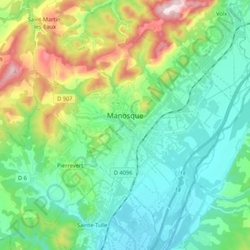
Name: Manosque topographic map, elevation, terrain.
Average elevation: 411 m
Minimum elevation: 274 m
Maximum elevation: 789 m
Make a donation
Gear up for your next adventure:
As an Amazon Associate, this site earns from qualifying purchases at no extra cost to you.
Other topographic maps
Click on a map to view its topography, its elevation and its terrain.
La Gravette
France > Provence-Alpes-Côte d'Azur > Alpes-de-Haute-Provence > Barcelonnette
Average elevation: 1,282 m
Chaumie Bas
France > Provence-Alpes-Côte d'Azur > Alpes-de-Haute-Provence > Chaumie
Average elevation: 1,677 m
Digne-les-Bains
France > Provence-Alpes-Côte d'Azur > Alpes-de-Haute-Provence > Digne-les-Bains > Digne-les-Bains
Average elevation: 791 m
Make a donation
Gear up for your next adventure:
As an Amazon Associate, this site earns from qualifying purchases at no extra cost to you.
Saint-Ours
France > Provence-Alpes-Côte d'Azur > Alpes-de-Haute-Provence > Val-d'Oronaye > Saint-Ours
Average elevation: 2,031 m
Ouvrage de Haut-Saint-Ours
France > Provence-Alpes-Côte d'Azur > Alpes-de-Haute-Provence > Val-d'Oronaye > Saint-Ours
Average elevation: 1,929 m
Fouillouse
France > Provence-Alpes-Côte d'Azur > Alpes-de-Haute-Provence > Saint-Paul-sur-Ubaye
Average elevation: 2,103 m