
Le Lienne topographic map
Interactive map
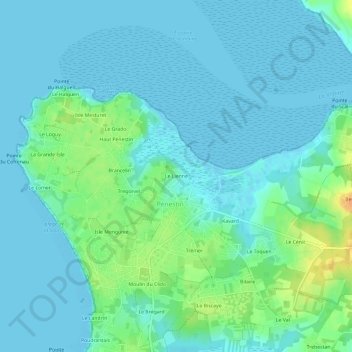
Click on the map to display elevation.
About this map
Name: Le Lienne topographic map, elevation, terrain.
Average elevation: 7 m
Minimum elevation: -1 m
Maximum elevation: 32 m
Other topographic maps
Click on a map to view its topography, its elevation and its terrain.
Poudrantais
France > Bretagne > Morbihan > Pénestin
Poudrantais, Pénestin, Vannes, Morbihan, Bretagne, France métropolitaine, 56760, France
Average elevation: 7 m
Le Landrin
France > Bretagne > Morbihan > Pénestin
Le Landrin, Pénestin, Vannes, Morbihan, Bretagne, France métropolitaine, 56760, France
Average elevation: 7 m