
Warmian-Masurian Voivodeship topographic map
Interactive map
Click on the map to display elevation.
About this map
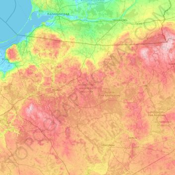
Name: Warmian-Masurian Voivodeship topographic map, elevation, terrain.
Location: Warmian-Masurian Voivodeship, Poland (53.13912 19.12764 54.45327 22.80614)
Average elevation: 105 m
Minimum elevation: -4 m
Maximum elevation: 296 m
Other topographic maps
Click on a map to view its topography, its elevation and its terrain.
Rysy
Poland > Lesser Poland Voivodeship > Tatra County > Brzegi
It is possible to reach the peak from the Slovak side, starting at Štrbské pleso and passing Chata pod Rysmi, a mountain chalet at an altitude of 2,250 m (7,380 ft). Between November 1 and June 15, the trail and chalet on the Slovak side are closed.
Average elevation: 2,005 m
Smogornia / Stříbrný hřbet
Poland > Lower Silesian Voivodeship > Karkonosze County > Borowice
Average elevation: 1,336 m
Grabiczek
Poland > Warmian-Masurian Voivodeship > Ostróda County > Wólka Lichtajńska
Average elevation: 118 m
Kable
Poland > Greater Poland Voivodeship > Czarnków-Trzcianka County > Klempicz
Average elevation: 73 m