
Thank you for supporting this site ❤️
Make a donation
Make a donation
Gear up for your next adventure:
As an Amazon Associate, this site earns from qualifying purchases at no extra cost to you.
Remondes topographic map
Click on the map to display elevation.
Thank you for supporting this site ❤️
Make a donation
Make a donation
Gear up for your next adventure:
As an Amazon Associate, this site earns from qualifying purchases at no extra cost to you.
About this map
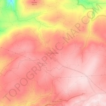
Name: Remondes topographic map, elevation, terrain.
Location: Remondes, Mogadouro, Distrito de Bragança, Portugal (41.35998 -6.78233 41.39998 -6.74233)
Average elevation: 661 m
Minimum elevation: 381 m
Maximum elevation: 758 m
Thank you for supporting this site ❤️
Make a donation
Make a donation
Gear up for your next adventure:
As an Amazon Associate, this site earns from qualifying purchases at no extra cost to you.
Other topographic maps
Click on a map to view its topography, its elevation and its terrain.
Vilarinho dos Galegos e Ventozelo
Portugal > Distrito de Bragança > Mogadouro
Average elevation: 646 m