
Jharaunu topographic map
Interactive map
Click on the map to display elevation.
About this map
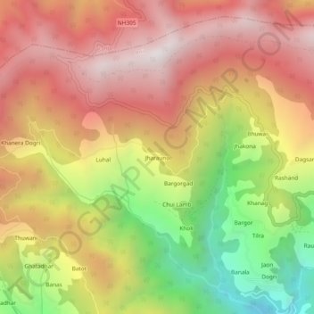
Name: Jharaunu topographic map, elevation, terrain.
Location: Jharaunu, Ani, Kullu District, Himachal Pradesh, India (31.50492 77.36555 31.54492 77.40555)
Average elevation: 2,664 m
Minimum elevation: 1,843 m
Maximum elevation: 3,285 m
Other topographic maps
Click on a map to view its topography, its elevation and its terrain.
Kamand
India > Himachal Pradesh > Ani
Kamand, Ani, Kullu District, Himachal Pradesh, 175038, India
Average elevation: 1,903 m
Serolsar Lake
India > Himachal Pradesh > Ani
Serolsar Lake, Ani, Kullu District, Himachal Pradesh, India
Average elevation: 2,979 m
Bae
India > Himachal Pradesh > Ani
Bae, Ani, Kullu, Himachal Pradesh, 172033, India
Average elevation: 1,230 m