
Ozo topographic map
Interactive map
Click on the map to display elevation.
About this map
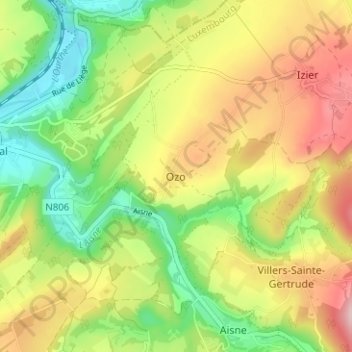
Name: Ozo topographic map, elevation, terrain.
Location: Ozo, Durbuy, Marche-en-Famenne, Luxemburg, Wallonië, België (50.35333 5.53578 50.39333 5.57578)
Average elevation: 219 m
Minimum elevation: 124 m
Maximum elevation: 332 m
Other topographic maps
Click on a map to view its topography, its elevation and its terrain.
À la Roche Plissée
België > Luxemburg > Marche-en-Famenne > Durbuy > Barvaux
À la Roche Plissée, Barvaux, Durbuy, Marche-en-Famenne, Luxemburg, Wallonië, 6940, België
Average elevation: 181 m
Grandhan
België > Luxemburg > Marche-en-Famenne > Durbuy
Grandhan, Durbuy, Marche-en-Famenne, Luxemburg, Wallonië, België
Average elevation: 204 m
Heyd
België > Luxemburg > Marche-en-Famenne > Durbuy
Heyd, Durbuy, Marche-en-Famenne, Luxemburg, Wallonië, België
Average elevation: 260 m
Borlon
België > Luxemburg > Marche-en-Famenne > Durbuy
Borlon, Durbuy, Marche-en-Famenne, Luxemburg, Wallonië, België
Average elevation: 274 m
Wéris
België > Luxemburg > Marche-en-Famenne > Durbuy
Wéris, Durbuy, Marche-en-Famenne, Luxemburg, Wallonië, België
Average elevation: 285 m
Villers-Sainte-Gertrude
België > Luxemburg > Marche-en-Famenne > Durbuy
Villers-Sainte-Gertrude, Durbuy, Marche-en-Famenne, Luxemburg, Wallonië, België
Average elevation: 255 m
Bende
België > Luxemburg > Marche-en-Famenne > Durbuy
Bende, Durbuy, Marche-en-Famenne, Luxemburg, Wallonië, België
Average elevation: 260 m
Septon
België > Luxemburg > Marche-en-Famenne > Durbuy
Septon, Durbuy, Marche-en-Famenne, Luxemburg, Wallonië, België
Average elevation: 236 m
Barvaux
België > Luxemburg > Marche-en-Famenne > Durbuy
Barvaux, Durbuy, Marche-en-Famenne, Luxemburg, Wallonië, 6940, België
Average elevation: 205 m
Bomal
België > Luxemburg > Marche-en-Famenne > Durbuy
Bomal, Durbuy, Marche-en-Famenne, Luxemburg, Wallonië, België
Average elevation: 202 m
Izier
België > Luxemburg > Marche-en-Famenne > Durbuy
Izier, Durbuy, Marche-en-Famenne, Luxemburg, Wallonië, België
Average elevation: 256 m
Tohogne
België > Luxemburg > Marche-en-Famenne > Durbuy
Tohogne, Durbuy, Marche-en-Famenne, Luxemburg, Wallonië, 6941, België
Average elevation: 225 m
Petit-Han
België > Luxemburg > Marche-en-Famenne > Durbuy
Petit-Han, Durbuy, Marche-en-Famenne, Luxemburg, Wallonië, 6940, België
Average elevation: 190 m