
Make a donation
Gear up for your next adventure:
As an Amazon Associate, this site earns from qualifying purchases at no extra cost to you.
Navacerrada topographic map
Click on the map to display elevation.
Make a donation
Gear up for your next adventure:
As an Amazon Associate, this site earns from qualifying purchases at no extra cost to you.
Navacerrada
Navacerrada is a municipality of the Community of Madrid, Spain. It lies at an elevation of 1,203 metres (3,947 ft) on the Reservoir Navacerrada and the entry of "Valle de la Barranca" in the Sierra de Guadarrama.
Make a donation
Gear up for your next adventure:
As an Amazon Associate, this site earns from qualifying purchases at no extra cost to you.
About this map
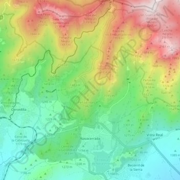
Name: Navacerrada topographic map, elevation, terrain.
Location: Navacerrada, Community of Madrid, 28491, Spain (40.71089 -4.04219 40.78840 -3.96863)
Average elevation: 1,460 m
Minimum elevation: 1,005 m
Maximum elevation: 2,267 m
Make a donation
Gear up for your next adventure:
As an Amazon Associate, this site earns from qualifying purchases at no extra cost to you.
Other topographic maps
Click on a map to view its topography, its elevation and its terrain.