
Make a donation
Gear up for your next adventure:
As an Amazon Associate, this site earns from qualifying purchases at no extra cost to you.
Ibagué topographic map
Click on the map to display elevation.
Make a donation
Gear up for your next adventure:
As an Amazon Associate, this site earns from qualifying purchases at no extra cost to you.
Ibagué
Ibagué features a tropical rainforest climate under the Köppen climate classification, albeit a relatively cooler version of the climate due to the high altitude. Although the city does experience noticeably drier conditions during and around the months of January and July, the city has no true dry season month, as all twelve months see on average more than 60 mm (2.4 in) of rain. As is commonplace in areas with this climate, temperatures are relatively consistent throughout the course of the year in Ibagué, with average high temperatures of about 28 °C or 82.4 °F and average low temperatures of about 18 °C or 64.4 °F. On average Ibagué sees 1,700 mm (66.9 in) of rain annually.
Make a donation
Gear up for your next adventure:
As an Amazon Associate, this site earns from qualifying purchases at no extra cost to you.
About this map
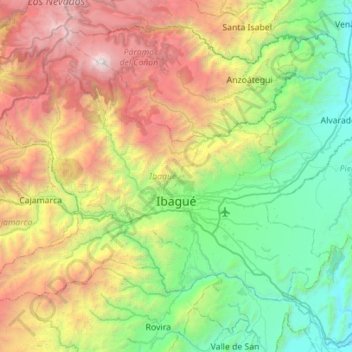
Name: Ibagué topographic map, elevation, terrain.
Location: Ibagué, Centro, Tolima, RAP (Especial) Central, Colombia (4.25786 -75.52470 4.69933 -74.96675)
Average elevation: 1,907 m
Minimum elevation: 308 m
Maximum elevation: 5,213 m
Make a donation
Gear up for your next adventure:
As an Amazon Associate, this site earns from qualifying purchases at no extra cost to you.