
Batangas topographic map
Interactive map
Click on the map to display elevation.
Batangas
Batangas is a combination of plains and mountains, including one of the world's smallest volcanoes, Mt. Taal, with an elevation of 600 metres (2,000 ft), located in the middle of the Taal Lake. Other important peaks are Mount Macolod with an elevation of 830 metres (2,720 ft), Mt. Banoy with 960 metres (3,150 ft), Mt. Talamitam with 700 metres (2,300 ft), Mt. Pico de Loro with 664 metres (2,178 ft), Mt. Batulao with 693 metres (2,274 ft), Mt. Manabo with 830 metres (2,720 ft), and Mt. Daguldol with 672 metres (2,205 ft).
About this map
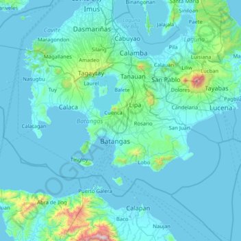
Name: Batangas topographic map, elevation, terrain.
Location: Batangas, Calabarzon, Philippines (13.47385 120.34558 14.24446 121.61033)
Average elevation: 126 m
Minimum elevation: -3 m
Maximum elevation: 2,532 m
Other topographic maps
Click on a map to view its topography, its elevation and its terrain.
Mount Pico de Loro
Philippines > Batangas > Nasugbu
Mount Pico de Loro, also known as Mount Palay-Palay, is a dormant volcano located on the border of Cavite and Batangas, in the island of Luzon, Philippines. It is the highest mountain in the province of Cavite, with an elevation of 2,257 ft (688 m) above sea level and the highest peak of the Mounts…
Average elevation: 359 m
Taal Bayview Subdivision
Philippines > Batangas > Taal > Taal Bayview Subdivision
Average elevation: 79 m