
Debre Birhan topographic map
Interactive map
Click on the map to display elevation.
Debre Birhan
Debre Birhan (Amharic: ደብረ ብርሃን) is a city in central Ethiopia. Located in the Semien Shewa Zone of Amhara Region, about 120 kilometers north east of Addis Ababa on Ethiopian highway 2, the town has an elevation of 2,840 meters, which makes it the highest town in Africa. It was an early capital of Ethiopia and afterwards, with Ankober and Angolalla, was one of the capitals of the kingdom of Shewa. Today, it is the administrative center of the North Shewa Zone of the Amhara Region.
About this map
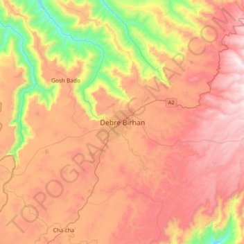
Name: Debre Birhan topographic map, elevation, terrain.
Average elevation: 2,720 m
Minimum elevation: 1,925 m
Maximum elevation: 3,383 m
Other topographic maps
Click on a map to view its topography, its elevation and its terrain.
Awi Agew
Topographically speaking, Agaw Awi is relatively flat and fertile, whose elevations vary from 1,800 to 3,100 m above sea level, with an average altitude of about 2,300 m. The Zone is crossed by about nine permanent rivers which drain into the Abay (or Blue Nile); other water features include two crater lakes,…
Average elevation: 1,640 m
Simien Mountains National Park
The vegetation is mixed with African alpine forests, wilderness forests and alpine vegetation. High altitude areas include montane savannah and tree heath (Erica arborea), giant lobelia (Lobelia rhynchopetalum), yellow primrose (Primula verticillata), everlastings (Helichrysum spp.), A lady's mantle…
Average elevation: 2,337 m
Bahir Dar Special Zone
Bahir Dar is located at the exit of the Abbay from Lake Tana at an altitude of 1,820 metres (5,970 ft) above sea level. The city is located approximately 578 km north-northwest of Addis Ababa. The Lake Tana region is a UNESCO Biosphere Reserve since 2015.
Average elevation: 1,794 m
Awi Agew
Topographically speaking, Agaw Awi is relatively flat and fertile, whose elevations vary from 1,800 to 3,100 m above sea level, with an average altitude of about 2,300 m. The Zone is crossed by about nine permanent rivers which drain into the Abay (or Blue Nile); other water features include two crater lakes,…
Average elevation: 1,640 m