
Oradour-sur-Vayres topographic map
Interactive map
Click on the map to display elevation.
About this map
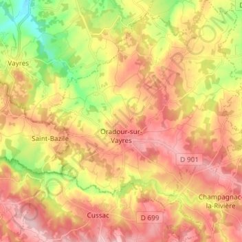
Name: Oradour-sur-Vayres topographic map, elevation, terrain.
Average elevation: 304 m
Minimum elevation: 208 m
Maximum elevation: 379 m
Other topographic maps
Click on a map to view its topography, its elevation and its terrain.
Les Rieux Vieux
France > Nouvelle-Aquitaine > Haute-Vienne > Saint-Pardoux-le-Lac
Average elevation: 380 m
Puy Chaffrat
France > Nouvelle-Aquitaine > Haute-Vienne > Les Grands-Chézeaux
Average elevation: 281 m