
Make a donation
Gear up for your next adventure:
As an Amazon Associate, this site earns from qualifying purchases at no extra cost to you.
Possession Island topographic map
Click on the map to display elevation.
Make a donation
Gear up for your next adventure:
As an Amazon Associate, this site earns from qualifying purchases at no extra cost to you.
Possession Island
The Alfred Faure research station (Base Alfred-Faure) is located at the eastern end of Île de la Possession, at an elevation of 143 m above Baie Marin (Port Alfred). It comprises about 12 main buildings and supports up to about 45 visiting personnel. It is named after a leader of the base in the 1960s. A 1.6 km road and aerial cableway connect the base to the sea, where supplies are brought by the vessel Marion Dufresne. The daily temperature at the site varies annually from an average high of 7.9°C to an average low of 2.7°C.
Make a donation
Gear up for your next adventure:
As an Amazon Associate, this site earns from qualifying purchases at no extra cost to you.
About this map
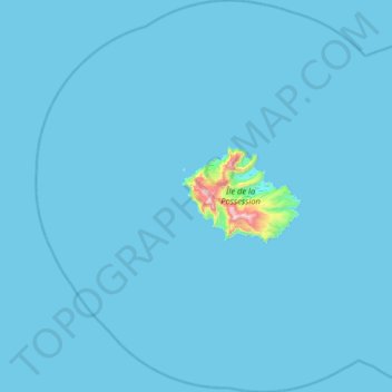
Name: Possession Island topographic map, elevation, terrain.
Average elevation: 13 m
Minimum elevation: 0 m
Maximum elevation: 897 m
Make a donation
Gear up for your next adventure:
As an Amazon Associate, this site earns from qualifying purchases at no extra cost to you.