Geolocate

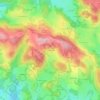
Flayat topographic map

Click on the map to display elevation.

About this map

Name: Flayat topographic map, elevation, terrain.

Location: Flayat, Aubusson, Creuse, Nouvelle-Aquitaine, Metropolitan France, 23260, France (45.72539 2.33122 45.83139 2.43378)

Average elevation: 765 m

Minimum elevation: 644 m

Maximum elevation: 873 m

Other topographic maps

Click on a map to view its topography, its elevation and its terrain.
Fursac

France > Nouvelle-Aquitaine > Creuse

Average elevation: 353 m

Bonnefond

France > Nouvelle-Aquitaine > Creuse > Janaillat

Average elevation: 532 m

Gear up for your next adventure:

🧶Camping String Lights - Ambience and utility lighting
👖Zip-off Hiking Pants - Adapt to changing Irish temperatures quickly
💺Camping Hammocks - Relax afloat camp setup
🫗Collapsible Water Bottles - Space‑saving hydration
🧴Anti-Chafe Sticks - Prevent friction during long distance walking

As an Amazon Associate, this site earns from qualifying purchases at no extra cost to you.