
Make a donation
Gear up for your next adventure:
As an Amazon Associate, this site earns from qualifying purchases at no extra cost to you.
Dehradun topographic map
Click on the map to display elevation.
Make a donation
Gear up for your next adventure:
As an Amazon Associate, this site earns from qualifying purchases at no extra cost to you.
Dehradun
The city stands at an elevation of 640 metres (2,100 ft) above sea level. Also known as the 'Abode of Drona', Dehradun has been an important center for Garhwal rulers and was captured by the British. For its strategic value, in addition to the location of its principal service academy, the Indian Armed Forces maintain a considerable presence in Dehradun, at the Garhi Cantonment and Naval Station. The Uttarakhand Police is the primary law enforcement agency in the city.
Make a donation
Gear up for your next adventure:
As an Amazon Associate, this site earns from qualifying purchases at no extra cost to you.
About this map
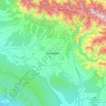
Name: Dehradun topographic map, elevation, terrain.
Location: Dehradun, Uttarakhand, 248001, India (30.16556 77.88368 30.48556 78.20368)
Average elevation: 904 m
Minimum elevation: 402 m
Maximum elevation: 2,568 m
Make a donation
Gear up for your next adventure:
As an Amazon Associate, this site earns from qualifying purchases at no extra cost to you.