
Make a donation
Gear up for your next adventure:
As an Amazon Associate, this site earns from qualifying purchases at no extra cost to you.
El Hatillo topographic map
Click on the map to display elevation.
Make a donation
Gear up for your next adventure:
As an Amazon Associate, this site earns from qualifying purchases at no extra cost to you.
El Hatillo
Debido a su altitud superior al promedio del resto del Área Metropolitana de Caracas, esta jurisdicción es reconocida como una de las zonas más frías del distrito capitalino, lo que influye tanto en su vegetación como en sus patrones de asentamiento y estilo de vida.
Make a donation
Gear up for your next adventure:
As an Amazon Associate, this site earns from qualifying purchases at no extra cost to you.
About this map
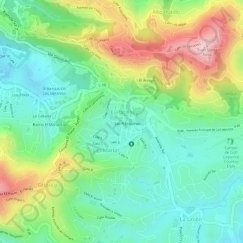
Name: El Hatillo topographic map, elevation, terrain.
Average elevation: 1,199 m
Minimum elevation: 1,092 m
Maximum elevation: 1,377 m
Make a donation
Gear up for your next adventure:
As an Amazon Associate, this site earns from qualifying purchases at no extra cost to you.
Other topographic maps
Click on a map to view its topography, its elevation and its terrain.
Sector Cantarrana
Venezuela > Estado Miranda > Municipio El Hatillo > Caracas
Average elevation: 1,165 m