
Make a donation
Gear up for your next adventure:
As an Amazon Associate, this site earns from qualifying purchases at no extra cost to you.
Huamantla topographic map
Click on the map to display elevation.
Make a donation
Gear up for your next adventure:
As an Amazon Associate, this site earns from qualifying purchases at no extra cost to you.
About this map
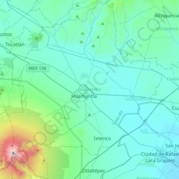
Name: Huamantla topographic map, elevation, terrain.
Location: Huamantla, Tlaxcala, Mexico (19.19257 -98.03952 19.45314 -97.80152)
Average elevation: 2,622 m
Minimum elevation: 2,352 m
Maximum elevation: 4,412 m
Make a donation
Gear up for your next adventure:
As an Amazon Associate, this site earns from qualifying purchases at no extra cost to you.
Other topographic maps
Click on a map to view its topography, its elevation and its terrain.
Huamantla
The municipality is located in the eastern half of the state of Tlaxcala, in the Central Mexican Highlands. It has an average altitude of 2,500 meters above sea level. The geography of the municipality has three types of relief. About twenty percent is rugged mountain (located in the far north and far south),…
Average elevation: 2,519 m
Make a donation
Gear up for your next adventure:
As an Amazon Associate, this site earns from qualifying purchases at no extra cost to you.
Tlaxcala City
Mexico > Tlaxcala > Municipio de Tlaxcala
The city is located in the central Mexican highlands 2,239 metres (7,346 feet) above sea level, in a valley of the same name, from which the Popocatépetl and Iztaccíhuatl volcanoes can be seen in the distance. The main elevations in the municipality are El Cerro Ostol at 2,460 metres (8,070 feet) and El…
Average elevation: 2,414 m