
Make a donation
Gear up for your next adventure:
As an Amazon Associate, this site earns from qualifying purchases at no extra cost to you.
Küstelberg topographic map
Click on the map to display elevation.
Make a donation
Gear up for your next adventure:
As an Amazon Associate, this site earns from qualifying purchases at no extra cost to you.
Küstelberg
Küstelberg befindet sich im Nordteil des Rothaargebirges als westnordwestlicher Stadtteil von Medebach. Es liegt zwischen den Bergen Hillekopf (804,9 m ü. NN) im Norden, Schlossberg (790 m) im Ost-Südosten sowie Großer Höcherkopf (764,3 m) und Reetsberg (792,2 m) im Süden und Halle (693,1 m) im Westen. Der Ortskern liegt an einer Stelle direkt nördlich der Kirche auf 666,1 m Höhe.
Make a donation
Gear up for your next adventure:
As an Amazon Associate, this site earns from qualifying purchases at no extra cost to you.
About this map
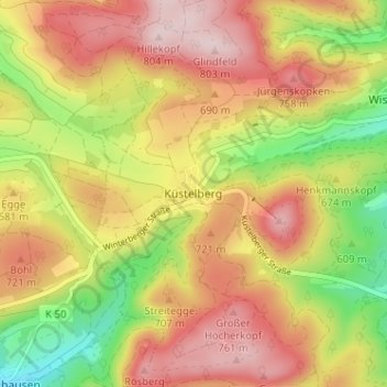
Name: Küstelberg topographic map, elevation, terrain.
Average elevation: 663 m
Minimum elevation: 500 m
Maximum elevation: 799 m
Make a donation
Gear up for your next adventure:
As an Amazon Associate, this site earns from qualifying purchases at no extra cost to you.
Other topographic maps
Click on a map to view its topography, its elevation and its terrain.
Knickhagen
Deutschland > Nordrhein-Westfalen > Hochsauerlandkreis > Medebach > Oberschledorn
Average elevation: 472 m
Kahle Pön
Deutschland > Nordrhein-Westfalen > Hochsauerlandkreis > Medebach > Titmaringhausen
Average elevation: 623 m