
Municipio de La Paz topographic map
Interactive map
Click on the map to display elevation.
About this map
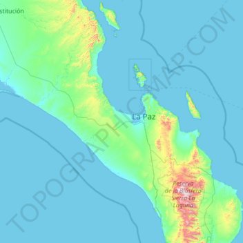
Name: Municipio de La Paz topographic map, elevation, terrain.
Location: Municipio de La Paz, Baja California Sur, Mexico (23.11403 -111.82083 25.11554 -109.69483)
Average elevation: 106 m
Minimum elevation: -1 m
Maximum elevation: 2,021 m
Other topographic maps
Click on a map to view its topography, its elevation and its terrain.
Cabo San Lucas
Mexico > Baja California Sur > Los Cabos Municipality
Cabo San Lucas, Los Cabos Municipality, Baja California Sur, 23470, Mexico
Average elevation: 94 m
La Ventana
Mexico > Baja California Sur > Municipio de La Paz
La Ventana, Municipio de La Paz, Baja California Sur, 23232, Mexico
Average elevation: 28 m
Ciudad Constitución
Mexico > Baja California Sur > Municipio de Comondú
Ciudad Constitución, Municipio de Comondú, Baja California Sur, 23600, Mexico
Average elevation: 54 m
Cerro el Frijol
Mexico > Baja California Sur > Municipio de Mulegé
Cerro el Frijol, Municipio de Mulegé, Baja California Sur, Mexico
Average elevation: 232 m
Isla Espíritu Santo
Mexico > Baja California Sur > Municipio de La Paz
Isla Espíritu Santo, Municipio de La Paz, Baja California Sur, Mexico
Average elevation: 50 m
Turtle Island
Mexico > Baja California Sur > Municipio de Mulegé
Turtle Island, Municipio de Mulegé, Baja California Sur, Mexico
Average elevation: 53 m
Los Cabos
Mexico > Baja California Sur > Los Cabos
Los Cabos, Baja California Sur, Mexico
Average elevation: 278 m
La Paz
Mexico > Baja California Sur > Municipio de La Paz
La Paz, Municipio de La Paz, Baja California Sur, 23020, Mexico
Average elevation: 114 m
San José del Cabo
Mexico > Baja California Sur > Los Cabos Municipality
San José del Cabo, Los Cabos Municipality, Baja California Sur, 23400, Mexico
Average elevation: 160 m
Isla Cerralvo
Mexico > Baja California Sur > La Paz
Isla Cerralvo, La Paz, Baja California Sur, Mexico
Average elevation: 81 m
El Sargento
Mexico > Baja California Sur > El Sargento
El Sargento, La Paz, Baja California Sur, 23232, Mexico
Average elevation: 42 m
Isla San Fransisco
Isla San Fransisco, La Paz, Baja California Sur, Mexico
Average elevation: 22 m
Isla Santa Margarita
Isla Santa Margarita, Comondú, Baja California Sur, Mexico
Average elevation: 26 m