
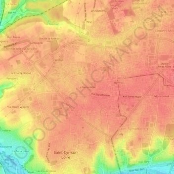
La Menardière topographic map
Interactive map
Click on the map to display elevation.
About this map
Name: La Menardière topographic map, elevation, terrain.
Average elevation: 92 m
Minimum elevation: 46 m
Maximum elevation: 106 m
Other topographic maps
Click on a map to view its topography, its elevation and its terrain.
Périgourd
France > Centre-Val de Loire > Indre-et-Loire > Saint-Cyr-sur-Loire
Périgourd, Saint-Cyr-sur-Loire, Arrondissement de Tours, Indre-et-Loire, Centre-Val de Loire, France métropolitaine, 37540, France
Average elevation: 85 m
Les Poulardières
France > Centre-Val de Loire > Indre-et-Loire > Saint-Cyr-sur-Loire
Les Poulardières, Saint-Cyr-sur-Loire, Arrondissement de Tours, Indre-et-Loire, Centre-Val de Loire, France métropolitaine, 37540, France
Average elevation: 70 m
La Lignière
France > Centre-Val de Loire > Indre-et-Loire > Saint-Cyr-sur-Loire
La Lignière, Saint-Cyr-sur-Loire, Tours, Indre-et-Loire, Centre-Val de Loire, France métropolitaine, 37540, France
Average elevation: 85 m
Pain Perdu
France > Centre-Val de Loire > Indre-et-Loire > Saint-Cyr-sur-Loire
Pain Perdu, Saint-Cyr-sur-Loire, Arrondissement de Tours, Indre-et-Loire, Centre-Val de Loire, France métropolitaine, 37540, France
Average elevation: 66 m
Mondoux
France > Centre-Val de Loire > Indre-et-Loire > Saint-Cyr-sur-Loire > Mondoux
Mondoux, Saint-Cyr-sur-Loire, Tours, Indre-et-Loire, Centre-Val de Loire, France métropolitaine, 37540, France
Average elevation: 84 m