
Macedonia - Thrace topographic map
Interactive map
Click on the map to display elevation.
About this map
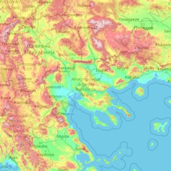
Name: Macedonia - Thrace topographic map, elevation, terrain.
Location: Macedonia - Thrace, Greece (39.86807 21.70420 41.74889 26.63558)
Average elevation: 530 m
Minimum elevation: -4 m
Maximum elevation: 2,848 m
Other topographic maps
Click on a map to view its topography, its elevation and its terrain.
Mytikas
Greece > Macedonia - Thrace > Mytikas
Mytikas, Δήμος Κομοτηνής, Rodopi Regional Unit, East Macedonia and Thrace Region, Macedonia - Thrace, 69100, Greece
Average elevation: 507 m