
Town of Wilton topographic map
Interactive map
Click on the map to display elevation.
About this map
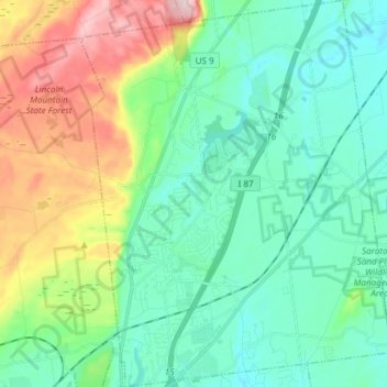
Name: Town of Wilton topographic map, elevation, terrain.
Average elevation: 140 m
Minimum elevation: 69 m
Maximum elevation: 331 m
Other topographic maps
Click on a map to view its topography, its elevation and its terrain.
Galway
United States > New York > Saratoga County > Galway
Galway, Village of Galway, Town of Galway, Saratoga County, New York, 12074, United States
Average elevation: 258 m
Barkersville
United States > New York > Saratoga County > Barkersville
Barkersville, Town of Providence, Saratoga County, New York, 12074, United States
Average elevation: 371 m