
Make a donation
Gear up for your next adventure:
As an Amazon Associate, this site earns from qualifying purchases at no extra cost to you.
Minamiaiki topographic map
Click on the map to display elevation.
Make a donation
Gear up for your next adventure:
As an Amazon Associate, this site earns from qualifying purchases at no extra cost to you.
Minamiaiki
Minamiaiki is located in mountainous eastern Nagano Prefecture, bordered by Gunma Prefecture to the east. More than 90% of the village area is covered by mountains and forest, and the village is at an average altitude of between 1000 and 1200 meters. Minamiaiki Dam is located within this village.
Make a donation
Gear up for your next adventure:
As an Amazon Associate, this site earns from qualifying purchases at no extra cost to you.
About this map
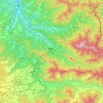
Name: Minamiaiki topographic map, elevation, terrain.
Average elevation: 1,299 m
Minimum elevation: 838 m
Maximum elevation: 2,075 m
Make a donation
Gear up for your next adventure:
As an Amazon Associate, this site earns from qualifying purchases at no extra cost to you.