
Make a donation
Gear up for your next adventure:
As an Amazon Associate, this site earns from qualifying purchases at no extra cost to you.
Ford End topographic map
Click on the map to display elevation.
Make a donation
Gear up for your next adventure:
As an Amazon Associate, this site earns from qualifying purchases at no extra cost to you.
About this map
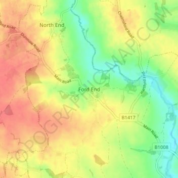
Name: Ford End topographic map, elevation, terrain.
Location: Ford End, Chelmsford, Essex, England, CM3 1LL, United Kingdom (51.80702 0.40939 51.84702 0.44939)
Average elevation: 65 m
Minimum elevation: 34 m
Maximum elevation: 90 m
Make a donation
Gear up for your next adventure:
As an Amazon Associate, this site earns from qualifying purchases at no extra cost to you.
Other topographic maps
Click on a map to view its topography, its elevation and its terrain.
Hanningfield Reservoir
United Kingdom > England > Essex > Chelmsford > South Hanningfield
Average elevation: 56 m
Make a donation
Gear up for your next adventure:
As an Amazon Associate, this site earns from qualifying purchases at no extra cost to you.
Make a donation
Gear up for your next adventure:
As an Amazon Associate, this site earns from qualifying purchases at no extra cost to you.
South Hanningfield
United Kingdom > England > Essex > Chelmsford > Ramsden Heath
Average elevation: 57 m