
Thank you for supporting this site ❤️
Make a donation
Make a donation
Gear up for your next adventure:
As an Amazon Associate, this site earns from qualifying purchases at no extra cost to you.
Sant'Elia topographic map
Click on the map to display elevation.
Thank you for supporting this site ❤️
Make a donation
Make a donation
Gear up for your next adventure:
As an Amazon Associate, this site earns from qualifying purchases at no extra cost to you.
About this map
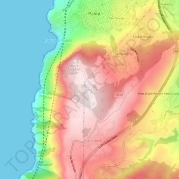
Name: Sant'Elia topographic map, elevation, terrain.
Location: Sant'Elia, Palmi, Reggio Calabria, Kalabrien, 89015, Italien (38.32044 15.82523 38.36044 15.86523)
Average elevation: 287 m
Minimum elevation: 0 m
Maximum elevation: 584 m
Thank you for supporting this site ❤️
Make a donation
Make a donation
Gear up for your next adventure:
As an Amazon Associate, this site earns from qualifying purchases at no extra cost to you.