
Make a donation
Gear up for your next adventure:
As an Amazon Associate, this site earns from qualifying purchases at no extra cost to you.
Siegen topographic map
Click on the map to display elevation.
Make a donation
Gear up for your next adventure:
As an Amazon Associate, this site earns from qualifying purchases at no extra cost to you.
Siegen
The city's total land area is roughly 115 km2 (44 sq mi). Its greatest east-west span is about 12 km (7 mi), and its greatest north-south span is about 12 km (7 mi). City limits are 48 km (30 mi) long. Siegen lies at a median elevation of 290 m (951 ft) above sea level. The city's greatest elevation is the peak of the Pfannenberg at 499 m (1,637 ft) above sea level at southern city limits. Siegen's lowest point is 215 m (705 ft) above sea level at Niederschelden at southwestern city limits, which there also forms the state boundary with Rhineland-Palatinate. Roughly 60% of the city's land is wooded, making Siegen one of Germany's greenest cities.
Make a donation
Gear up for your next adventure:
As an Amazon Associate, this site earns from qualifying purchases at no extra cost to you.
About this map
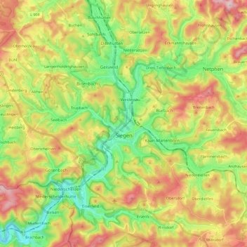
Name: Siegen topographic map, elevation, terrain.
Average elevation: 346 m
Minimum elevation: 199 m
Maximum elevation: 540 m
Make a donation
Gear up for your next adventure:
As an Amazon Associate, this site earns from qualifying purchases at no extra cost to you.
Other topographic maps
Click on a map to view its topography, its elevation and its terrain.
Obernberg
Germany > North Rhine-Westphalia > Kreis Siegen-Wittgenstein > Bad Laasphe
Average elevation: 488 m
Rüppershausen
Germany > North Rhine-Westphalia > Kreis Siegen-Wittgenstein > Bad Laasphe
Average elevation: 497 m
NSG Erzebachtal
Germany > North Rhine-Westphalia > Kreis Siegen-Wittgenstein > Kreuztal > Fellinghausen
Average elevation: 329 m
Make a donation
Gear up for your next adventure:
As an Amazon Associate, this site earns from qualifying purchases at no extra cost to you.
Heisberg
Germany > North Rhine-Westphalia > Kreis Siegen-Wittgenstein > Freudenberg
Average elevation: 338 m
Siegen
Germany > North Rhine-Westphalia > Kreis Siegen-Wittgenstein > Siegen
The city's total land area is roughly 115 km2 (44 sq mi). Its greatest east-west span is about 12 km (7 mi), and its greatest north-south span is about 12 km (7 mi). City limits are 48 km (30 mi) long. Siegen lies at a median elevation of 290 m (951 ft) above sea level. The city's greatest elevation is the…
Average elevation: 401 m