
Wadgaon J. topographic map
Interactive map
Click on the map to display elevation.
About this map
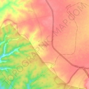
Name: Wadgaon J. topographic map, elevation, terrain.
Location: Wadgaon J., Kalamb, Dharashiv, Maharashtra, 413405, India (18.30730 75.91747 18.34730 75.95747)
Average elevation: 674 m
Minimum elevation: 615 m
Maximum elevation: 696 m
Other topographic maps
Click on a map to view its topography, its elevation and its terrain.
Kalaspur
India > Maharashtra > Kalamb
Kalaspur, Kalamb, Yavatmal, Maharashtra, 445401, India
Average elevation: 249 m
Manjara Dam
India > Maharashtra > Kalamb > Karanjakalla
Manjara Dam, Karanjakalla, Kalamb, Osmanabad, Maharashtra, India
Average elevation: 650 m