
Make a donation
Gear up for your next adventure:
As an Amazon Associate, this site earns from qualifying purchases at no extra cost to you.
Betulia topographic map
Click on the map to display elevation.
Make a donation
Gear up for your next adventure:
As an Amazon Associate, this site earns from qualifying purchases at no extra cost to you.
About this map
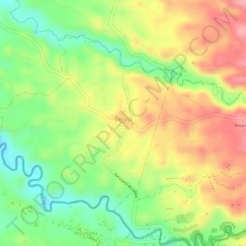
Name: Betulia topographic map, elevation, terrain.
Average elevation: 1,243 m
Minimum elevation: 1,177 m
Maximum elevation: 1,303 m
Make a donation
Gear up for your next adventure:
As an Amazon Associate, this site earns from qualifying purchases at no extra cost to you.
Other topographic maps
Click on a map to view its topography, its elevation and its terrain.
Make a donation
Gear up for your next adventure:
As an Amazon Associate, this site earns from qualifying purchases at no extra cost to you.
Crucero de Combia
Colombia > Risaralda > AMCO, Area Metropolitana Centro Occidente
Average elevation: 1,266 m
Make a donation
Gear up for your next adventure:
As an Amazon Associate, this site earns from qualifying purchases at no extra cost to you.
Alto Cerritos
Colombia > Risaralda > AMCO, Area Metropolitana Centro Occidente
Average elevation: 1,169 m
Quebrada Dos Quebradas
Colombia > Risaralda > AMCO, Area Metropolitana Centro Occidente
Average elevation: 1,396 m
Altagracia
Colombia > Risaralda > AMCO, Area Metropolitana Centro Occidente
Average elevation: 1,473 m
Make a donation
Gear up for your next adventure:
As an Amazon Associate, this site earns from qualifying purchases at no extra cost to you.