
Herne topographic map
Interactive map
Click on the map to display elevation.
About this map
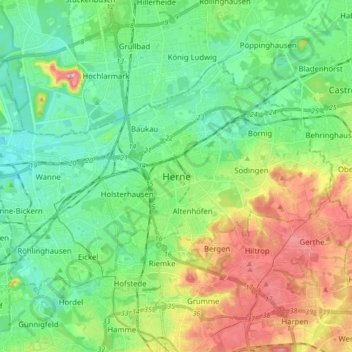
Name: Herne topographic map, elevation, terrain.
Location: Herne, North Rhine-Westphalia, Germany (51.50308 7.12364 51.57335 7.29650)
Average elevation: 71 m
Minimum elevation: 31 m
Maximum elevation: 152 m
Other topographic maps
Click on a map to view its topography, its elevation and its terrain.
Siedlinghausen
Germany > North Rhine-Westphalia > Hochsauerlandkreis > Winterberg
Average elevation: 563 m