Geolocate

Redwood County topographic map

Interactive map

Click on the map to display elevation.

About this map

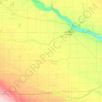
Name: Redwood County topographic map, elevation, terrain.

Location: Redwood County, Minnesota, United States (44.19497 -95.59456 44.69854 -94.86219)

Average elevation: 326 m

Minimum elevation: 247 m

Maximum elevation: 448 m

Other topographic maps

Click on a map to view its topography, its elevation and its terrain.

St. Vincent

United States > Minnesota > Kittson County

St. Vincent, Kittson County, Minnesota, 56755, United States

Average elevation: 241 m

Lismore

United States > Minnesota > Nobles County

Lismore, Nobles County, Minnesota, United States

Average elevation: 510 m

Le Sueur County

United States > Minnesota

Le Sueur County, Minnesota, United States

Average elevation: 310 m

Lucan

United States > Minnesota > Redwood County

Lucan, Redwood County, Minnesota, United States

Average elevation: 331 m

Clontarf

United States > Minnesota > Swift County

Clontarf, Swift County, Minnesota, 56226, United States

Average elevation: 318 m

Glenville

United States > Minnesota > Glenville

Glenville, Freeborn County, Minnesota, United States

Average elevation: 374 m

Clearwater County

United States > Minnesota

Clearwater County, Minnesota, United States

Average elevation: 409 m

Rosemount

United States > Minnesota > Dakota County

Rosemount, Dakota County, Minnesota, 55068, United States

Average elevation: 287 m

Coleraine

United States > Minnesota > Coleraine

Coleraine, Itasca County, Minnesota, 55722, United States

Average elevation: 408 m

Tower

United States > Minnesota > Tower

Tower, Saint Louis County, Minnesota, United States

Average elevation: 427 m